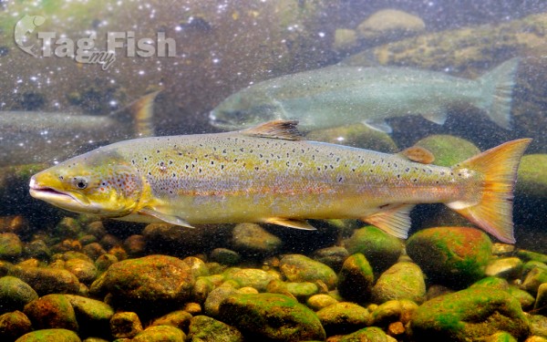
Salmoniformes - Salmons and Trouts
The River Tay is the longest river in Scotland and the seventh-longest in Great Britain. The Tay originates in western Scotland on the slopes of Ben Lui (Scottish Gaelic: Beinn Laoigh), then flows easterly across the Highlands, through Loch Dochart, Loch Iubhair and Loch Tay, then continues east through Strathtay (see Strath), in the centre of Scotland, then southeasterly through Perth, where it becomes tidal, to its mouth at the Firth of Tay, south of Dundee. It is the largest river in the British Isles by measured discharge. Its catchment is approximately 2,000 square miles (5,200 km2), the Tweed\\\\\\\\\\\\\\\’s is 1,500 square miles (3,900 km2) and the Spey\\\\\\\\\\\\\\\’s is 1,097 square miles (2,840 km2).
The Tay is internationally renowned for its salmon fishing and is one of the best salmon rivers in western Europe, attracting anglers from all over the world. The lowest ten miles of the Tay, including prestigious beats like Taymount or Islamouth, provide most of the cream of the Tay. The largest rod caught salmon in Britain, caught on the Tay by Georgina Ballantine in 1922, weighing 64 pounds (29 kg), retains the British record.
The river system has salmon fisheries on many of its tributaries including the Earn, Isla, Ericht, Tummel, Garry, Dochart, Lyon and Eden. Dwindling catches include a 50% reduction in 2009 so the Tay District Salmon Fisheries Board ordered a catch-and-release policy for females all season, and for males until May, beginning in the January 2010 fishing season. Research by the North Atlantic Salmon Conservation Organisation has shown that the number of salmon dying at sea has doubled or trebled over the past 20 years, possibly due to overfishing in the oceans where salmon spend two years before returning to freshwater to spawn. The widespread collapse in Atlantic salmon stocks suggests that this is not solely a local problem in the River Tay.