
Largest tributaries

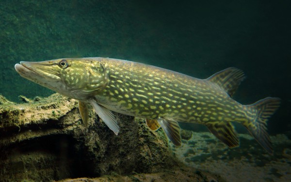
Esociformes - Pikes
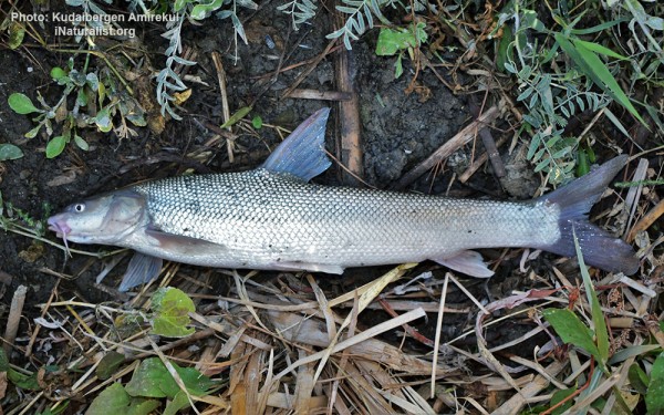
Cypriniformes - Carps
The ex Aral Sea
The Aral Sea was an endorheic lake lying between Kazakhstan (Aktobe and Kyzylorda Regions) in the north and Uzbekistan (Karakalpakstan autonomous region) in the south, which began shrinking in the 1960s and had largely dried up by the 2010s. The name roughly translates as Sea of Islands, referring to over 1,100 islands that had dotted its waters.
Formerly the fourth largest lake in the world with an area of 68,000 km2 (26,300 sq mi). The Aral Sea began shrinking in the 1960s, when the Soviet Union decided that the two rivers feeding it, the Amu Darya and the Syr Darya, would be diverted to irrigate cotton and food crops in Kazakhstan and Uzbekistan.
By 1997, it had declined to 10% of its original size, splitting into four lakes: the North Aral Sea, the eastern and western basins of the once far larger South Aral Sea, and the smaller intermediate Barsakelmes Lake.
By 2009, the southeastern lake had disappeared and the southwestern lake had retreated to a thin strip at the western edge of the former southern sea. In subsequent years occasional water flows have led to the southeastern lake sometimes being replenished to a small degree.
Satellite images by NASA in August 2014 revealed that for the first time in modern history the eastern basin of the Aral Sea had completely dried up. The eastern basin is now called the Aralkum Desert.
The North Aral Sea
The North Aral Sea is the portion of the former Aral Sea that is fed by the Syr Darya River.
It split from the South Aral Sea in 1987–1988 as water levels dropped due to river diversion for agriculture.
There is now an ongoing effort in Kazakhstan to save and replenish the North Aral Sea. The poorly built Dike Kokaral intended to contain the North Aral Sea and save its fisheries failed twice, but in 2005, the government of Kazakhstan was able to fund a more robust design. Thanks to a nearly $86 million project financed in large part by the World Bank. Along with repairs to existing dikes around the basin to prevent spillage, a 12 mile dam was constructed just south of the Syr Darya River.
It was built across a narrow stretch of the Aral Sea, splitting off the North Aral Sea (also called The Small Sea) from the much larger South Aral Sea (The Large Sea). The dike is conserving the dwindling waters of the Syr Darya river and maintaining (and attempting to revive) the damaged ecology of the North Aral Sea, at the expense of sealing the fate of the larger South Aral.
Completed in the summer of 2005, this dam, named Kokaral, surpassed all expectations. It led to an 11-foot increase in water levels after just seven months—a goal that scientists initially expected would take three years.
After the completion of Dike Kokaral, water level of the North Aral has risen, and its salinity has decreased.
The water level had risen by 12 m (39 ft) from its level by 2003. Economically significant stocks of fish have returned, and observers who had written off the North Aral Sea as an environmental catastrophe were surprised by reports that in 2006 its returning waters already were partly reviving the fishing industry and producing a catch for export as far as Ukraine.
The restoration reportedly gave rise to long absent rain clouds and possible microclimate changes, bringing tentative hope to an agricultural sector swallowed by a regional dustbowl, and some expansion of the shrunken sea. The sea, which had receded almost 100 kilometres (62 mi) south of the port-city of Aralsk, is now a mere 12 kilometres (7.5 mi) away as of 2015.
Plans to build a second dike to increase water levels further were due to begin in 2010, but have so far not materialized.


